You're viewing free preview questions — 4 questions previewing here — subscribe to unlock 30 more, plus the Full Question Bank, Mock Papers & Worksheets.Upgrade
Bearings and Scale Drawings — Free MYP4 Mathematics (Extended) Practice Questions

1QuestionMeasuring and Drawing BearingsConcept Practice
2 marks~3 minCriterion A
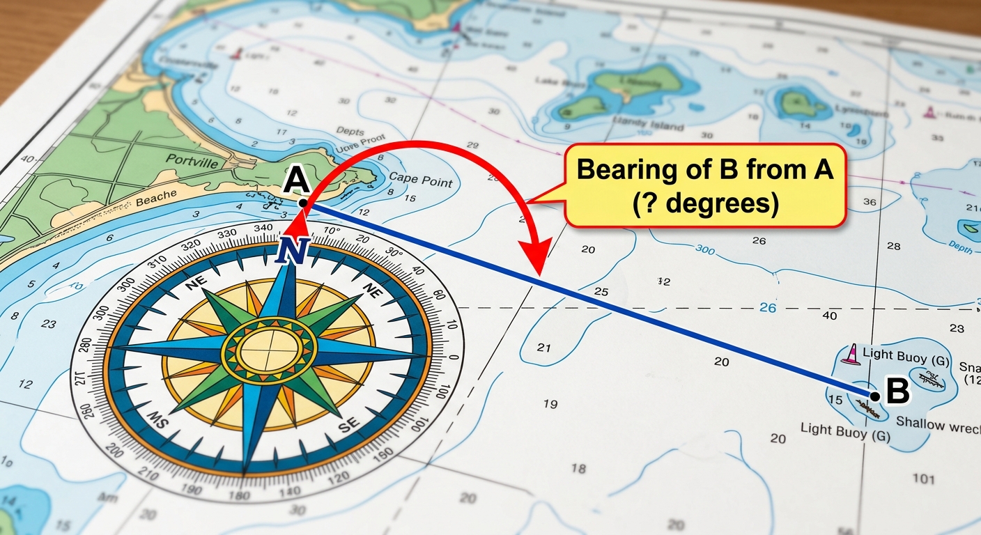
A coast guard vessel departs from port A. A north line is shown at A. Point B marks a lighthouse.
a
Determine the three-figure bearing of B from A. [1]
b
The coast guard must travel on a bearing of to reach a rescue zone C from A. Justify whether the lighthouse at B or the rescue zone at C is further clockwise from north when viewed from A. [1]

Solutions
2QuestionUnderstanding Bearings in NavigationAssessment Practice
6 marks~9 minCriterion D
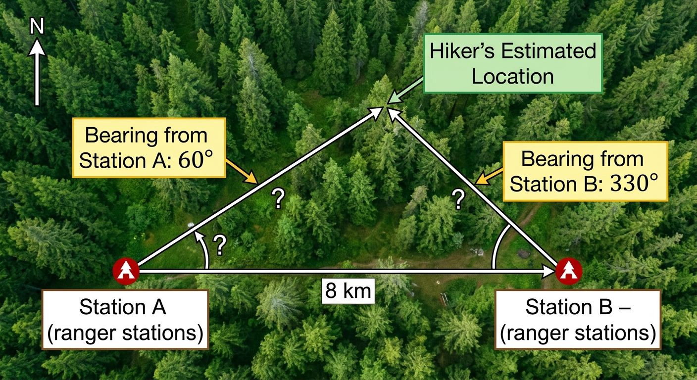
A search and rescue team uses bearings to locate a lost hiker. Station A and Station B are 8 km apart, with Station A directly west of Station B. Station A detects the hiker on a bearing of and Station B detects the hiker on a bearing of .
a
Deduce the size of each interior angle in triangle , where is the hiker's estimated location. [2]
b
Calculate the distance from Station A to the hiker's estimated location. [2]
c
The rescue team deploys a helicopter when the hiker is more than 3.5 km from Station A, and a ground team otherwise. Advise the rescue coordinator which option to deploy, and explain one reason why the mathematical model may make this advice unreliable. [2]
Solutions
3QuestionCreating and Interpreting Scale DiagramsAssessment Practice
6 marks~9 minCriterion D
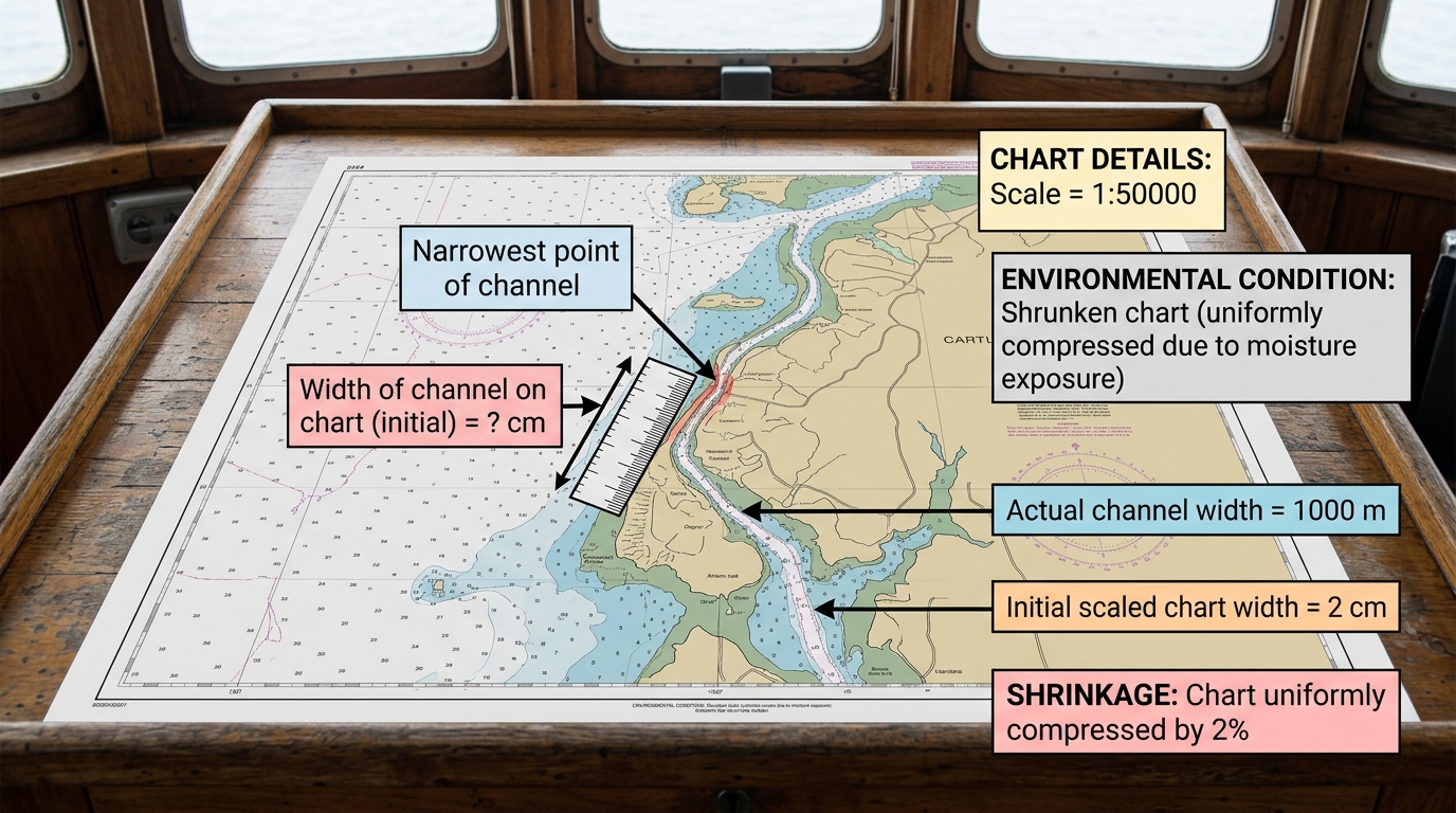
A nautical chart has a scale of 1:50 000. A narrow channel measures 2 cm wide on the chart, representing an actual width of 1 000 m. The chart has been exposed to moisture and has uniformly shrunk by 2%.
a
Calculate the new width of the channel on the shrunken chart. [2]
b
Deduce the new scale of the shrunken chart, expressing your answer in the form , and calculate the percentage error in the scale compared to the original. [2]
c
The ship is 900 m wide. Advise the captain whether the shrunken chart can be used safely to navigate the channel, justifying your advice with calculations of the actual clearance on each side of the ship. [2]
Solutions
4QuestionCreating and Interpreting Scale DiagramsAssessment Practice
6 marks~9 minCriterion B
A cartographer is creating maps of the same region at different scales. The table below shows the relationship between scale factor and the measured map distance between two landmarks.
The actual distance between the two landmarks remains constant throughout.
| Scale factor denominator | 5 000 | 10 000 | 20 000 | 40 000 |
|---|---|---|---|---|
| Map distance (cm) | 20 | 10 | 5 | 2.5 |
The actual distance between the two landmarks remains constant throughout.
a
Analyse the relationship between the scale factor denominator and the map distance, identifying any pattern. [2]
b
Deduce the map distance between the landmarks on a map with scale factor 1:80 000, showing your reasoning clearly. [2]
c
A cartographer claims that a map distance of 8 cm is suitable for a printed map where the minimum legible distance between two labelled landmarks is 6 cm. Identify the scale factor that produces this 8 cm map distance and justify whether the cartographer's claim is valid. [2]
Solutions
That's every free question here — 4 of 34.
+30 more questions, plus Mock Papers & Worksheets, are waiting in Premium.